Record Hurricane Drought, Real Roof Damage: A September Nor’easter Did What the Tropics Couldn’t
The Atlantic reached Sept. 21 without a hurricane for the first time since 1914. Days later a looping nor’easter slammed New Jersey with gusts to 74 mph, 4+ inches of rain and Sandy-level erosion — and ripped a YMCA roof off.
 Ridge Report
3 min read
Ridge Report
3 min read

The Atlantic hit a mark nobody alive has seen. On Sept. 21, WCAX meteorologist Gunnar Consol reported that the basin had reached late September with six named storms and zero hurricanes — the first season to get to Sept. 21 without a hurricane since 1914. Only 1907 and 1914 finished an entire season hurricane-free in records going back to 1851.
Four days later, a slow, looping nor’easter showed why that stat doesn’t pay your crews’ overtime or protect your customers’ roofs. Starting Friday night, Sept. 25, the storm hammered New Jersey with heavy rain, tidal flooding and gusts over 50 mph, and ripped the roof off the YMCA on Wits End Road in Hardyston, according to Patch. A roofing company was dispatched the next morning.
What the nor’easter left behind
Shore Local Newsmagazine’s Sept. 28 damage rundown put real numbers on the weekend:
- Wind: 74 mph gust at Point Pleasant (hurricane-force), 69 mph at Harvey Cedars, 67 mph on Long Beach Island, 61 mph near Avalon and Wildwood, 57 mph in Atlantic City and 54 mph at Cape May Harbor.
- Rain: More than 4 inches in parts of Atlantic and Cape May counties, led by about 4.75 inches in Hammonton.
- Tide: Saturday’s high tide in Ocean City reached 7.63 feet (MLLW), nearly matching the 7.66-foot mark from the January 2016 Jonas nor’easter.
- Erosion: Atlantic City Beach Patrol called it the worst erosion since Sandy in 2012.
- Power: About 21,000 homes and businesses across New Jersey, New York, Connecticut and Massachusetts were still dark early Monday.
Farther north, the New England Storm Center described a cutoff low that bottomed out near 985 mb and parked south of New England for nearly three days, damaging part of the Scituate, Mass., seawall along with some homes.
Meanwhile in the tropics: close, but no hurricane
The Atlantic wasn’t empty — it just couldn’t close the deal. Tropical Storm Fay formed Sept. 19 and nearly became the season’s first hurricane before wind shear knocked it back; the National Hurricane Center issued its final advisory on post-tropical Fay on Sept. 29. Gonzalo spun up near Cape Verde on Sept. 25 and fell apart within about a day. Hanna was named Sept. 28 east of Bermuda, and NHC wrote its last advisory on Sept. 30 after shear stripped its convection.
As of NHC’s 8 p.m. EDT outlook on Oct. 2, the only feature on the Atlantic map was Fay’s leftovers southeast of Bermuda, with formation odds near 0% over both 48 hours and seven days.
Don’t confuse quiet with safe
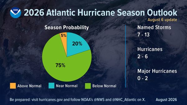
NOAA’s August update still called for 7–13 named storms and 2–6 hurricanes on the season, and the agency is clear that a seasonal outlook says nothing about whether your county gets hit. We made that case in NOAA’s below-normal outlook still leaves a one-storm problem — and the nor’easter proved the point without a tropical name attached. WCAX also noted that late-season systems can still develop in the western Caribbean and southern Gulf.
For Northeast shops, the next two weeks are inspection-and-repair season. For Gulf and Southeast shops, the record drought is a gift of time: restock tarps and dry-in material, tighten your 48-hour storm-response checklist, and keep claim intake staffed. If 2026 stays hurricane-free through Nov. 30, it becomes only the third such season on record — but nobody should bid their fall calendar on that.
Sources
WCAX, Sept. 21, 2026. Patch, Sept. 28, 2026. Shore Local Newsmagazine, Sept. 28, 2026. New England Storm Center, Sept. 28, 2026. NHC Fay Discussion 39. NHC Hanna Discussion 9. NHC Atlantic Tropical Weather Outlook.