NOAA Called 2026 Below-Normal — Mid-Season Is Still a One-Storm Problem
NOAA’s Aug. 6 update held a 75% below-normal Atlantic call (7–13 named, 2–6 hurricanes). For roofing shops, outlook ≠ zero risk — one landfall still fills the calendar. Prep cash, staging, and files.
 Ridge Report
3 min read
Ridge Report
3 min read
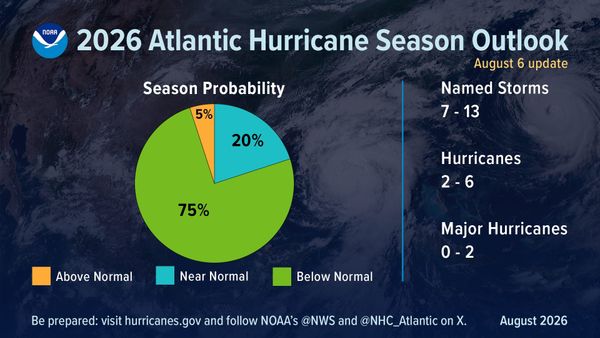
NOAA’s August 6, 2026 mid-season update kept the Atlantic call below-normal: 75% chance below-normal, 20% near-normal, 5% above-normal. Updated ranges: 7–13 named storms, 2–6 hurricanes, 0–2 majors — inclusive of early-season storms and centered well below the 1991–2020 averages (about 14 / 7 / 3). El Niño, which emerged in June and strengthened through summer, is the dominant suppressor via wind shear.
For roofing shops, that outlook is useful planning context — and a terrible reason to stand down. NOAA itself stresses the seasonal outlook is not a landfall forecast. One landfalling system still fills calendars, yards, and claim queues.
What NOAA / NHC put on the record
- May outlook: Below-normal season; initial ranges roughly 8–14 named, 3–6 hurricanes, 1–3 majors (per NOAA’s later comparison).
- Aug. 6, 2026 update: Probabilities hardened to 75% / 20% / 5%; ranges trimmed to 7–13 / 2–6 / 0–2, including storms already formed.
- Early season (through the August update): Tropical Storms Arthur and Bertha — both Gulf-born; no hurricanes yet at that update. Arthur brought heavy Louisiana rain and tornadoes; Bertha made landfall in St. Bernard Parish, LA.
- Driver: Strengthening El Niño increasing shear; Atlantic SSTs near average and a neutral West African monsoon as lesser factors (NOAA).
- Mid-September context: Trade and national weather coverage into mid-September still described a historically quiet Atlantic stretch with no hurricanes formed deep into the season — consistent with the below-normal call, not a guarantee the rest of the season stays empty.
“Inland rainfall is a major cause of damage from tropical storms and hurricanes… That’s why it’s important to prepare for every storm that’s projected to impact your area, even if it never reaches hurricane strength,” Ken Graham, NOAA NWS Director, said in the Aug. 6 release.
Why “below-normal” still books out shops
Seasonal ACE and named-storm counts are basin statistics. Your P&L cares about landfall, inland flooding, and tornadoes under tropical rainbands. Arthur and Bertha already illustrated the point: named storms that never become major hurricanes can still drive leak calls, soft-metal collateral, and emergency dry-ins along the Gulf.
- One landfall = weeks of ops: Intake surge, dumpsters, ice-and-water, and crew overtime do not wait for a Category 3.
- Outlook ≠ zero risk: NOAA’s own framing: landfalls are short-range weather, skillful only about a week out via NHC. Keep watching hurricanes.gov.
- Quiet seasons punish the unprepared: Shops that drained storm cash, let tarp inventory lapse, or stopped documenting standards get hurt hardest when the one system that matters hits their ZIP codes.
Ops checklist while the basin stays quiet
- Cash and deposits: Keep a storm float. Percentage deductibles and slow supplements still apply when a tropical rainmaker shows up.
- Staging: Confirm tarp, drip edge, ice-and-water, and ridge-vent buffers with your yard — quiet basins often mean yards thin “storm” SKUs to cut carrying cost.
- Crew readiness: Refresh door-knock and documentation SOPs before the first watch. Peak months historically still concentrate activity in ASO even in quieter years.
- Marketing discipline: Don’t promise “no storms this year.” Promise response speed and file quality if one arrives.
- Pacific contrast: NOAA kept an above-average Eastern Pacific call — irrelevant to Atlantic landfall odds, but a reminder climate patterns are not “no weather.”
The Ridge Report take: honor NOAA’s below-normal call for planning inventory and overtime budgets — then run the shop as if the next named storm could still be your quarter. Outlooks set the odds; one track sets your week.
Grounded in NOAA’s Aug. 6, 2026 mid-season Atlantic outlook release, CPC Atlantic hurricane outlook page, and NOAA’s seasonal framing that outlooks are not landfall forecasts (NHC / hurricanes.gov for watches and warnings).
Related: Storm season hits hard · Gulf/Midwest corridors.